Satellite Imagery:
NHC Latest Satellite Imagery
IR Atlantic Wide View [GOES-EAST]

Atlantic Wide View
GeoColor Image – Loop – Animated GIF
Visible Image – Loop – Animated GIF
Shortwave-IR Image – Loop – Animated GIF
IR Image – Loop – Animated GIF
Water Vapor Image – Loop – Animated GIF
IR Gulf of Mexico [GOES-EAST]
 Gulf of Mexico
GeoColor Image – Loop – Animated GIF
Visible Image – Loop – Animated GIF
Shortwave-IR Image – Loop – Animated GIF
IR Image – Loop – Animated GIF
Water Vapor Image – Loop – Animated GIF
IR Caribbean [GOES-EAST]
 Caribbean
GeoColor Image – Loop – Animated GIF
Visible Image – Loop – Animated GIF
Shortwave-IR Image – Loop – Animated GIF
IR Image – Loop – Animated GIF
Water Vapor Image – Loop – Animated GIF
IR Atlantic Coast [GOES-EAST]
 US Atlantic Coast
GeoColor Image – Loop – Animated GIF
Visible Image – Loop – Animated GIF
Shortwave-IR Image – Loop – Animated GIF
IR Image – Loop – Animated GIF
Water Vapor Image – Loop – Animated GIF
|
Current Storm Information:
National Hurricane Center
NRL Monterey Marine Meteorology Division
Ocean Prediction Center
Tropicaltidbits.com
Mike's Weather Page
Cyclonic Wx
Univ. Wisc-Mad CIMSS
Power Outage Map
SFC/ UPP Air Analyses
Current Sea Surface Temps
 Atlantic Surface Analysis
Full Ocean
|| West Atlantic
|| East Atlantic
Wind/Wave Analysis
Significant Wave Height
GWES Probabilistic Wave Height Guidance
SST Composite
GOES Satellite-Derived Sea Surface Temperatures
Ocean Model SST Areas (Forecasts)
Ocean Model Current Areas
Atlantic Upper Air Analysis
NHC Previous 24hr Pressure Changes
Advanced Scatterometer Imagery
Current Low Level Winds
Current Upper Level Winds
Shear Tendency
Wind Shear Map
850mb Vorticity
500mb Vorticity
250mb Vorticity
Steering Current Map
Computer Models
Tropical Tidbits
GFS
|| ECMWF
|| CMC
|| HRRR
CyclonicWx.com Model Page
Weathernerds TC Model Page
Univ. Albany Tropical Model Page
PSU Tropical e-WALL
DuPage/Nexlab Model Page
NOAA HFIP Page
NHC Track and Intensity Model Summary
Buoy/Recon Data
National Data Buoy Center
NHC Recon Page
For Today (text issued yesterday)
||For Tomorrow (text issued today)
Tropical Tidbits Recon Page
Coastal Radars
Northeast Regional Sector Map
Southeast Regional Sector Map
Gulf Coast East Regional Sector Map
Gulf Coast West Regional Sector Map
Historical
Atlantic Tropical Cyclone Climatology
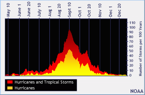
Tropical Cyclone Climatology
Tropical Cyclone Names
Most Extreme Tropical Cyclones
NHC Data Archive
Past Track Seasonal Maps
Hurricane Database Re-Analysis Project
|


