|
 Clifty Creek:
March 30, 2013
Sipsey Wilderness, AL
Distance: 8 miles
[View Photo Gallery]
With perfect weather for one last off trail adventure before the snakes came out of hiding for good, I decided to explore Clifty Creek, a fairly well known area I’ve somehow always managed to avoid in several years of hiking the Sipsey Wilderness. Known for its ruggedness, and the beauty of the falls at the head of the canyon, it seemed a great way to cap off a season of cold weather hiking excursions. It wasn’t cold that day, though a bit cool and overcast, with a chance of heavy rain moving in late. I was pretty certain I could do this out and back adventure and be back with time to spare before the rain hit.
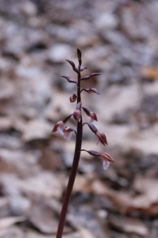
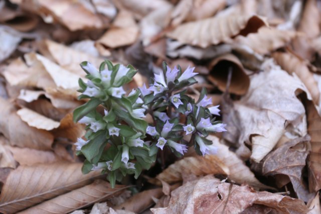
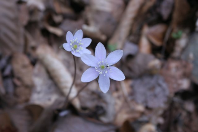
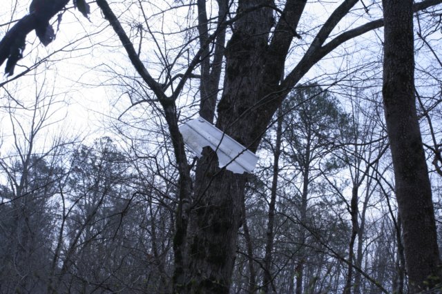
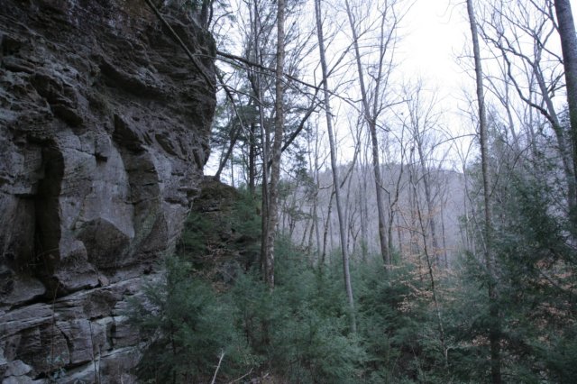
I parked at the Borden trailhead, where I took note of a chainsaw in the bed of a pick up truck on the side of the road. To the right of it, was a large dome canopy with an equally large tent and many chairs, coolers, grills, car seats, i.e., a wilderness area’s worst nightmare. I documented it all with photographs in case the need arose for them later, and set out on my journey. Crossing the bridge, I headed upstream on Borden Creek, and did a double take at a little plant I had not expected to see here, Spring Coralroot. This plant had been on my bucket list of things to see in bloom for quite some time, and I was thrilled to find another small grouping not far from the current cluster. It didn’t really make much sense for this little plant to be in bloom now, but I certainly wasn’t complaining! The water level in the creek was up from all the rain we’d received the previous week, but I hoped that not having to cross any major streams would help keep my feet good and dry for the length of this trip. The recent storms downed a large beech tree across the trail with not much way over it than to just plow right on through, breaking and bending what branches I could. Just past the tree where the trail gets narrow with a lot of bamboo a large population of pennywort had sprouted! Without a doubt the most I’d ever seen in one place, and I’ve always been fond of the tiny little things. Lots of other little wildflowers had started sprouting near here as well, with bellwort and some iris just peeking above the soil. I took note of an old tree carving hidden by some low tree limbs that read “Pat + William” before crossing the first seasonal stream, which was really flowing quite well. I stopped shortly after crossing to photograph some saxifrage in bloom, first I’ve seen of it this season, before climbing down the steep bank here to tracks of deer, raccoon and something canine in the sandy mud. Moving on, I stopped to photograph a popular camping spot, really a shadow of it’s former self. So many trees here have fallen since I first visited the spot about 3˝ years ago from many windstorms and a possible tornado. I kept up my pace here a bit, as this section of Braziel I’ve seen many times before, and I wanted to save as much time as I could to explore all that I could of Clifty. I passed the turn off to ‘ray of light’ falls, and kept on up the old road bed, which was extremely muddy in areas. The lack of foliage finally allowed me to spot the junction of Clifty and Braziel Creeks, something I always like to photograph and document, but this would be a rather steep climb down the embankment. That steep climb, however, was rewarded with an absolute field of Virginia bluebells, some in full bloom, including one that was solid pink! The variety of wildflowers changed here as well, with a warmer microclimate and much more sun. I stumbled across everything from star chickweed and allegheny spurge to wood vetch and pussytoes. The climb back up to the old road wasn’t as bad, and the view up Clifty started out nice, with giant moss covered boulders in the stream. High up in one of the trees I spotted a piece of vinyl siding wedged here from a tornado two years ago. It was a stark reminder of that devastating day all across the state, and but a taste of what I’d find right around the corner. After following a very steep game trail uphill and rounding the bend, the forest went from mixed hardwood and hemlock to utter destruction. Had I stayed low by the creek it would have been nearly impossible to maneuver through all of the dead, fallen and half fallen trees. Looking above on the ridge above the bluff line, nearly every tree in view had been snapped like a pencil and tossed down into the canyon. I decided to explore and photograph a lot of the damage here, which required me to make my way downhill, using a lot of the deadfall as handholds in spots.
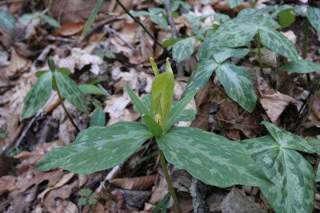
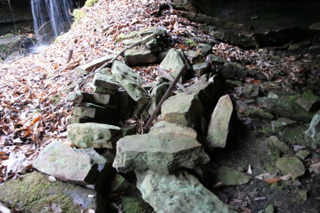
 Once again by the creek, the canopy loss was quite large. It was hard to even see the creek through the downed trees here in spots. Travel was slow going for a bit, but I finally made it back onto a game trail of sorts, and kept on the level ground close to the creek here as much as I could. I came across a small stream, and caught movement; a huge deer up close to the bluff line saw me first and bounded away before I could snap a photo of him. It made me decide to explore upstream and see what I could find, though from this view it looked like nothing impressive. After a little rock hopping and climbing over some deadfall, I found deer tracks and the place he’d been drinking from. I also saw a bit of a hidden waterfall! A little more uphill walking revealed a 30ft or so waterfall with a nice shelter behind it. This would be a great spot to hang out were it to rain, and one of a few spots I’d seen thus far. The shelter behind the falls ended up being pretty muddy, and there were several wallows the pigs had dug. I hopped another large fallen tree, and made my way down and around the bend, and straight into the heart of another tornado damage path, this one worse than the previous one I’d encountered. After a long hard climb downhill, I found the creek again. I hopped over to a little island and stopped for a break and to check my coordinates only to find my gps unit missing. Somewhere in the last half mile it’d popped out of my camera bag’s side pocket. Considering the terrain and deadfall I’d gone through, there was very little chance of me finding it. So, instead of spending the rest of the time searching for it, I kept on going upstream, having to reply on map and compass for directions and a fairly useless cell phone for time. The next feeder stream looked promising on the map, so I hopped it and followed a game trail high up on the steep banks, and walked right into an absolute ocean of trillium! I finally got to see one of my favorites, the lemon trillium, and also found some lanceleaf trillium that were very small, the flower only being about as large as my thumbnail. This waterfall I could now see and hear very well and looked about 25-30ft high. Climbing the long stack of rocks to the left of falls revealed a narrow crevice, deep crevice between the rock pile and the actual back of the shelter itself. I could see lots of little ferns and what looked like the typical mold one finds in shelters with bats, though I never found one. After a restful lunch, I explored the narrow area, but it didn’t lead anywhere, and I turned my attention to the other side of the falls, where I found some filmy ferns. Slipping between two big rocks, I found a very wet area with a lot of liverwort, and I backtracked to avoid smashing through what looked like an area that’d never been touched, even by the wildlife. Heading back toward the junction I came across some sessile trillium, something I don’t see terribly often and some bellwort very close to being in bloom. Back on Clifty, I took up the game trail again that led past some shallow stone mounds [I’ve always heard these were slave burial mounds in some parts of the forest, but no way of discerning what these are exactly], and enjoyed the lack of undergrowth beneath the hemlocks for change. The next stream junction brought with it a much larger creek than anticipated and also a very nice, clean campsite. After looking over the map a bit, I knew there was a chance of seeing some additional waterfalls up this drainage, so that’s the way I went.
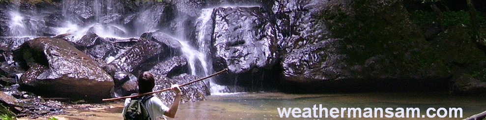
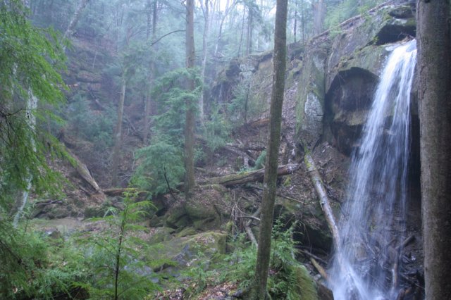
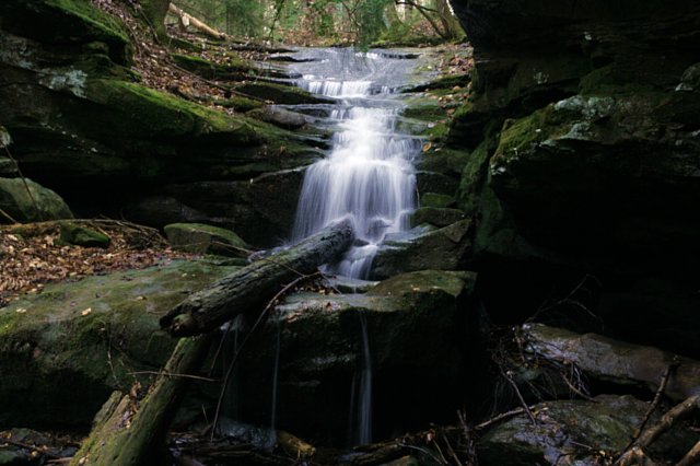 The clouds by now were beginning to thicken up, but still the threat of rain seemed distant and minimal. The forest was very open through here which made for easy hiking next to the unnamed creek. I could see a small waterfall off to the left, but decided it wasn’t worth the work to get up to the bluff to explore, so I continued on to the junction of the two significant streams that made up this canyon. I opted to go to the left one first, and soon came across a tree with some odd markings on it. Whether they were native american arborglyphs or not I have no idea, as they were too worn to discern much more than a general outline of. I came across a very small set of cascades, followed by a large cascade mostly obscured by fallen trees. This raised hopes of finding a really decent waterfall upstream. Those hopes were quickly dashed when I stumbled upon the “head” of the canyon, with nothing more than a 7ft waterfall. Disgruntled, something out of place caught my eye beneath the very short shelter that surrounded the falls. The remnants of an old moonshine still! There was a lot of rebar and other chunks of rusted metal lying around, and I took some time to see what different components I could spot. I checked the map again, and with the feeder arm I passed looking more promising from a topological standpoint, I quickly made my way back downstream, staying high on a very faded game trail. It was very hard to keep your footing here, but soon leveled out, and also quickly ended in disappointment. This waterfall only measured about 4-5ft tall, and was completely unworthy of the effort it took to make it upstream to see. Feeling a bit put out by it all, I very much considered just skipping the last arm of the canyon altogether, but decided against it. The walk upstream was much easier, and there was a weird large mound of rocks, though it mostly looked like a natural occurrence. The canyon walls began to rise, and so did my spirits a bit. And while the waterfall was still more of a cascade and small, it was nice, at least, and reminded me a bit of Deer Skull Falls , but I’m not certain why. Walking back downstream, I found a taller, but definitely seasonal falls, spilling over the edge of the bluff, and yet another arborglyph too degraded to make out. All my worries about rain came to fruition, suddenly, as sprinkles turned into a light shower that slowly became heavier as I neared the junction with Clifty Creek. From the map I could tell there was probably another quarter to half mile of walking at least before I reached Clifty Falls , my potential turn around point. I kept up a decent pace here, stopping at times to admire the boulders and the creek, and seek shelter from heavier bursts of rain. I came to a junction with a small stream on the other side of the creek, but with no easy way across and essentially out of time now that the rain had commenced, I simply took a photo of the humongous boulder sitting at the intersection for future reference, and headed on. The terrain leveled out a bit briefly, and an old logging road joined in, which made for easy hiking for a little ways. The road quickly disappeared again, and I followed a narrow game trail where a slide meant a good 15ft tumble down on into the creek below. Across the creek, I spotted the first of three waterfalls at the head of the canyon, the first one falling a good 60ft with a nice shelter behind it. The rain was coming down in buckets now, and I ducked into a small rock shelter briefly, before scurrying downhill and beneath a thick hemlock that mostly shielded me from the rain while I took photos of the last two falls. This was a truly primitive area, and ranks in the top ten spots I’ve seen in Sipsey or Bankhead. Crossing the Creek, I stopped in the shelter there and fashioned a poncho out of an emergency blanket, if for no other reason than to try and keep my camera dry as I was already pretty soaked by now.
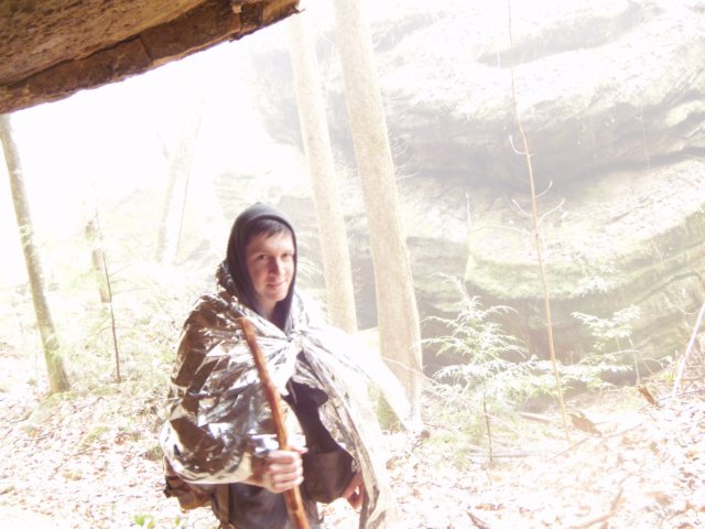 After waiting for a bit to see if the rain would subside, I decided to study the map a bit and see if it were feasible to make my way cross country to trail 224, a route that would put me back at the jeep much quicker. I crossed the creek again, and climbed up a steep, muddy section of land using tree roots to get up and out of the canyon. While this may have been a game trail, it certainly wasn’t easy to do. I checked the map again against the compass and set out northwest as best I could, though taking whatever game trails I could find. I stumbled across an old gas can of some kind, probably from the moonshine making days before finally reaching a little ridgeline of some kind. I was certain the trail was just out of view, but the brush was so thick I ended up walking in circles, finding a piece of my emergency blanket that’d torn off. Not sure where I was, I wandered into an intermittent stream drainage just to get to some body of water of some kind, and saw movement. I stopped and watched as pig after pig wandered upstream, rooting through the mud in the center of the drain. I was still way up closer to the ridgeline, out of sight and apparently out of nose, as about a dozen, mostly smaller black pigs and one much larger, almost hairless pig ventured past. Once they were safely gone, I made my way down to the stream and set out as quick as my soaked feet could take me toward whatever bigger stream I happened to be heading toward. The compass at this point wasn’t working very well, requiring me to bang it on something to get it to function at all. I finally heard some rushing water, and was excited, thinking I was at least somewhere downstream on Clifty, but I wasn’t. I’d done a complete loop, and was back exactly where I started, except now next to the other main waterfall in the upper part of the canyon. I made my way down a very narrow, slick pig print covered trail down to the base and pulled out my map to see what went wrong. It was apparent now that the ridge I hit was not the one I wanted, but I should have crested it, gone down and hit the next ridge where the trail really lay. I scaled back up the same steep muddy spot where I started, and set out again, this time completely ignoring any game trail and just relying on the compass directions. I hopped the ridge, went down into the drainage where I found a 55 gallon drum flipped upside down with a metal pan laying on top. I had a weird feeling about it all, and just kept on going uphill, hanging a right where the stream split before finally disappearing. I made the second ridge, with an old road bed, and a lot of deadfall, but no trail in sight. Looking at the map, I was confused again as to where I was exactly. I decided following the old road couldn’t hurt, and as long as I stayed south, or southwest, it would eventually lead me somewhere back downstream on Clifty. The road went sharply downhill finally, and disappeared, leaving me on the edge of the bluff with no real way down. Frustrated, I hiked back uphill and turned down the other dry branch the way I came, and began hiking downstream. I laughed as I realized I’d put myself on top of the unimpressive waterfall with the still site, and made haste back to the stream junction with Clifty. Now I ran the risk of running out of daylight unless I made lightning speed back to the trailhead, and I did just that. Tired and soaked, with the rain still coming down hard at times, I sloshed my way back to the jeep and headed on home.
|